Showing posts with label None. Show all posts
Showing posts with label None. Show all posts
Thursday, March 10, 2011
Tuesday, Wednesday 8-9 March : game over man, game over!
A vacation DNF?
We've had a couple of tough days, which have led to some hard choices. After a day and a half of closed-shop frustration (very reminiscent of our days in Puerto natales, at the other end of our trip), we finally got the rear wheel disassembled to a point we could assess the damage. The news was not good. Not only were the bearing races very worn, but the axel itself is badly damaged. Of course, the axel is longer than that of a standard bike and so getting a new one would take at least 6-10 working days. This would leave us with too little time to do anything beyond prepare to fly home. This left us with 3 broad options :
1 - ship the bike home now, buy some rucksacks and spend the next couple of weeks backpacking
2 - leave the bike in Mendoza for a couple of weeks and go backpacking (or car rental), returning to Mendoza to fly home
3 - arrange to get ourselves and the bike home as soon as practical.
There are actually a number of hybrid options too, but all fundamentally depend on us being able to get the bike out of Mendoza - and neither of us are confident that it can be safely ridden anywhere with a worn axle (and especially after the tender ministrations of the 'friendly' bike shop mechanic this morning), which means bus and air are the only options. By disassembling the bike, we make it more likely that a bus company or airline will carry it, but it also increases the chances of it being damaged in transit, and increases the amount of packaging we need to find. In a major city which seems to contain less cone spanners than are currently sitting in our garage, this could be a problem. The other issue is that we both desperately wanted to cycle a 'proper' Andean high pass. That is to say, something more than you find in Europe, or anywhere outside the Himalayas for that matter. In fact, one of the reasons we didn't do the ripio pass over Cristo Redentor was that we didn't feel the need to knowing we had big plans on cycling the Agua Negro pass, as our last big experience which in many ways the rest of the tour had been planned as a build up to. Doing anything else now feels like we would simply be filling the time merely for the sake of it.
So, since I started writing this, we've now decided to try and fly ourselves and the bike home in the next few days. After an afternoon trying to organise all the different options, it seems like the sensible choice. It may yet be something we'll look back on as the wrong decision, but given we've known for a couple of months that we want to come back to South America one day, it doesn't feel so bad.
So, this evening was spent dismantling and preparing Dobbin for a couple flights on an airline that doesn't take tandems (!), drinking wine, and using up some of the food and fuel we'd been stockpiling for our final expedition up to the remote, 4700m altitude Andes pass. A more relaxing end to our trip in some ways, but leaves some significant unfinished business. We've learnt a lot about the tandem, our equipment and ourselves over the last 2+ months. Next time we will be even better prepared, both in terms of expectations of our equipment and of ourselves.

Tuesday, March 8, 2011
Monday 7th March : the horse is lame
So, we're stuck in Mendoza with a broken bike!
We had a good morning cycling up and over the final ridge and a fantastic (if very hazy) view on the descent to the plain and Mendoza. About 25km out of the city the freewheel on the bike finally gave up. It started misbehaving a few weeks into the trip, and the pedals would go around when you pushed the bike forward. It failed 'fixed' rather than 'free' fortunately, so we could pedal, but not freewheel. We've always wanted to try a fixed wheel tandem, but never thought that Dobbin would fit that category! Unlike a true fixed wheel bike we could still change gear (just), and the bike wouldn't give you a little kick to remind you to keep pedaling - the excess chain would wind itself around the cassette instead. We fortunately had found a non documented, decent, non motorway route into the city as the cycling was interesting enough as it was! This eventually led to a very good quality new cycle path leading right into the city (following a disused railway line embankment) but unfortunately the town has the UK affliction of forgetting to signpost where you will get to should you follow said cycle path! (Germany on the other hand was great, even labeling cities hundreds of km away and across borders!)
The freehub is not a serviceable part (although it can be replaced), and we had hoped that it would last until we got back to the UK where we were thinking of replacing the entire hub. The chances of finding a replacement 48 spoke tandem hub in south America is very slim, and time wise, there is no point in trying to ship a hub here.
On the way into town we saw many people out on road bikes, and we wondered whether it was a public holiday here. The tourist information centre confirmed that today and tomorrow are public holidays and that all the bike shops would be closed on both days. We wanted to take the wheel apart to assess the damage before visiting a bike shop, so we got places in a hostel with a large garden (and swimming pool) around the back. A closer examination of the wheel indicated that the problem with the hub was not as simple as we first thought, and that there was significant resistance to the wheel turning at all! The axel is off centre on the drag brake side, and the central part of the drag brake appears to have split and turned oval! Unfortunately we can't confirm the problem, or assess the damage to the hub as we didn't bring the correct tool with us - we have removed the cassette, but can't disassemble the hub. There are many bike rental places here (including the hostel), but none seem to have any bike maintenance tools. So we are stuck in Mendoza with a broken bike for a couple of days. Fortunately this is the centre of the Argentinian wine region, so there is plenty to do. We're hoping that the bike is fixable though and we can continue our cycling adventure.
map
Monday, March 7, 2011
Sunday 6 Mar: definitely back in Argentina now
The 200km descent didn't entirely live up to expectations. The first hour was pretty fair traveling, but then we refound our old friend, Argentine headwind. The clouds had cleared overnight so it was a dry day, but very windy. It isn't supposed to be that strong this far north, and it is meant to prevail from the west, yet there it was in our faces as we traveled east, and then south after lunch. We somehow pretty much avoided any wind in our previous sortie into Argentina, in the lake district, so maybe this was to make up for it.
The Rio Mendoza valley is spectacular scenery though, so our stunted speed was not without its benefits. The rock is red and orange and green and black at various points, and interesting shaped with oddly angled strata throughout.
Also, entertainment was found playing spot the (disused) railway line, seeing the bridges and tunnels it follows and landslides it disappears under. At one point in the afternoon we saw a couple people with a motorbike making their way up the abandoned line! Not sure how they were coping with the collapsed sections and crumbing embankments above the fast flowing river. The Mendoza river is popular for white water rafting, and we saw several rafts on the river. There didn't seem to be a great deal of white water though, and like most of the rivers we've seen flowing out of the Andes in this area, the water was definitely a muddy brown colour.
As well as windy, this valley road is less monotonic in its ascent to the pass, and by lunch we'd already climbed over 800m despite being on the downhill direction!
By 5pm we were pretty warn out from battling the wind, barely managing 10mph downhill in places, so we gave up on any plans of making it to Mendoza, and stopped in Potrerillo with some 50km still to go. This is a slightly odd town, the recent (ish, I think) dammed river has forced the road to reroute and bypass the town, but they seem to have forgotten to put up much in the way of signs to let you know what the town offers, or that it's even there. We eventually found the campsite, after climbing several km around the bypass to drop back down into the town and discover we needed to get back across the town to a few hundred meters of where the road had passed on the way in!
So, in all not the elusive hundred miler day we thought it might have been, but 127km it was still our longest yet of this tour, and 1500m of climb and the headwind, not an inconsiderable one.
map
Sunday, March 6, 2011
Saturday 5 Mar: look Dobbin, mountains!

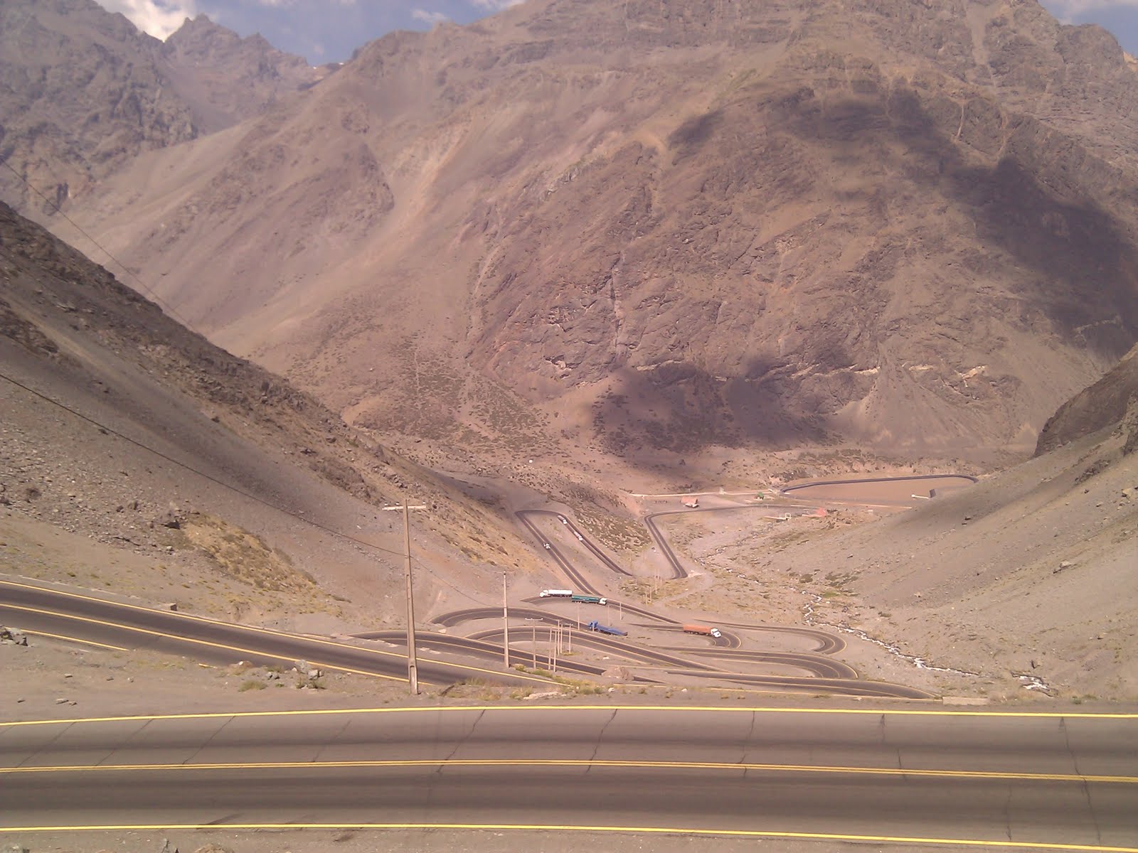
Wel, Damion was right when he said cycling at altitude makes you fart!
I missed the 6:30 alarm due to having ear plugs in, but Emma informs me there was one. We made it out the tent just after 7 by which time daylight was making itself visible, although we had to cycle up the valley a way before the sun finally popped out from beside a mountain to warm us up.
Loaded up with soft drinks at Rio Blanco, but we didn't see the old engine sheds that apparently remain there. Next the road started to ascend more, in short but occasionally steep ramps between rolling sections along the valley. It was starting to feel like it could be a tough old day, but at least the sun was not overbearing nor the traffic unbearable.
Around the 93km marker (20k on from last nights stop) we passed another campsite. Given a longer day leaving Los Andes that could make a better camp before starting the main ascent, especially if one was intending to tackle the longer route over the top of the pass.
Shortly after midmorning snack, we turned a corner to see the first of the hairpins, and we knew the real climb was about to begin.
There are 29 numbered switchbacks in all (photo), the first 20 in one tightly woven set and the rest up the remainder of the ascent to the portillo ski resort. There's something really quite magical about climbing switchbacks. (In a strange way they're more fun to go up than down - for tandem descents we prefer nice straight roads which makes this pass a perfect choice for doing in the direction we are going). As you climb you get a real feeling of your progress. And it was very noticeable that this was the point that passengers started leaning out of passing cars cheering and taking photos, which just got louder and more frequent the further up we got. At one point we even saw a juggernaut driver taking a snap of us, whilst simultaneously negotiating an inside lane hairpin bend!
The portillo ski resort is at about 2800m but with no snow anywhere in sight it was a strange image. We pressed on past, around a long stretch of roadworks, and then through a long covered section of road that we were glad to put on the rear lights for. Then, on emerging we saw the flags that mark the start of the 3km tunnel between the countries, and off to the right the dirt track that leads up to the Cristo Redentor monument that stands at the summit of the natural pass. Decision time. At this point we were at 3200m, the highest we'd ever cycled, and the highest we'd been with full touring luggage by about 2 vertical km! It's another 600+ meters up to the summit, and as the weather was looking suspect and the day getting on, we decided the sensible option was to take the tunnel. Not that we're big fans of sensible options!
Bikes are not permitted through the tunnel, but a very efficient system is in place such that within a couple minutes of reaching the entrance a man appeared with a small truck and loaded the bike and luggage in, for a free lift through to Argentina. Whereas motor vehicles get to pay to drive through!
Sure enough, we emerged the other side into a rain shower that soon turned to hail, feeling glad we'd already donned rain jackets before loading the bike on the van as it's the most convenient way to carry them.
After 15km of rapid if damp going on painful descent we reached customs, which is very strangely a combined Chile / Argentine post. Very odd to see the respective authorities sharing offices and chatting to one another, when the early crossings we did in the south still have multi kilometer demilitarized zones to stop them taking shots at one another - or so it feels like!
Beyond the customs point is puento del Inca, an intriguing natural bridge with small settlement built around it, where we have stopped to camp. This area has base camps for folks attempting ascent of cerro Aconcagua, so has quite a different feel to the ski resort the other side. The valley is completely different too, being long and stretched out, and rocks of amazingly varied colours from what we have seen so far; looking forward to seeing more on the 200km descent to Mendoza tomorrow!
map
Friday, March 4, 2011
Thursday 3 March : to Santiago, and then some
The bus journey to Santiago was a success - two Things and one Dobbin arrived safe and well. Although we managed some sleep on the bus, we were both still rather tired however so abandoned any plan of trying to cycle to Los Andes, and decided to just try to get out of town. Like any large city you are not familiar with, Santiago is difficult to enter/exit when riding a bike, especially as all the roads shown on our map exiting the city are motorways, and any others would be dirt tracks! We had read on a webpage that a good way to exit was to use the Piedra Roja Pass, which starts in a posh suburb in the north east of the city and is not a motorway. Navigating to the suburb is also fairly straightforward, and uses the main road (avenue liberator Bernard O Higgins), through the centre of the city. There was even an off road bike path for some of it. We stopped a couple of times for late breakfasts, finding a cafe near the map shop recommended in our guidebook where we wanted to get some more detailed maps of the city and borders. By 11 it still wasn't looking like it might open though, so we carried on and then had lunch at a cafe next to a bike shop on the east side of town. The shop owner was very helpful, lending us a track pump and spending some time searching for the slightly unusual European style inner tubes we use (MTB size tyres with presta valves: while performing the maintenance in Temuco, we realised that we had managed to bring a spare tube which wouldn't work with these rims as the valve is too large). On the bus overnight I'd noticed the outside temperature steadily climbing, with it reaching 20 degrees before dawn on the outskirts of the city. It's definitely a bit warmer here than further south! Shortly after lunch we had our first navigational issue, as the bridge we wanted to use to cross the river is a restricted access road. We could see the road we wanted to take on the other side of the river, but there was no way to reach it. The detour involved a small climb which gave a good, but very hazy view of the city, and we eventually found the pass. Unfortunately, for no good reason we could see this road was also restricted access - no bikes, lorries, buses or horse drawn vehicles. We decided to ignore the signs and carry on as the only other option was to return to the centre and try and hitch (the short distance buses are too small for a tandem). There were a number of exclusive new developments on the road, and we thought the signs were possibly like those sometimes found in the US - more socially oriented than for safety. We certainly saw a few posh road bikes on the road, and it remained safe and wide for it's entire length. The views descending the far side were great, but again, very hazy. Having reached Colina and ruta 57, we noted the motorway feel of the road and the the 'cycling prohibited' signs. While people do cycle on this road, we really didn't want to, and with no obvious accommodation nearby we decided to try and hitch a lift to Los Andes. The first Dobbin sized vehicle stopped (a small enclosed lorry), and the luggage was quickly loaded into the back, with us in the front. We had difficulty understanding where the driver was going to drop us off, but understood that he was taking a load of tomatoes to Argentina. We were dropped at the toll booths prior to the motorway tunnel where our driver was taking a dirt road to collect his load, and made our way to the other side. There were many more vehicles here than our previous hitching point. A recovery truck soon stopped and after strapping Dobbin and luggage on the back we made it to Los Andes, and the end of the motorway (for now). It was a useful day as we got to do a bit of climbing in the heat, and also confirmed that hitching with the bike is quite possible. We are planning to have an easy day tomorrow and cycle the first (valley) part of the climb to Mendoza, leaving the main climb (switchbacks) for the following morning.
map
Monday, February 28, 2011
Friday and Saturday 25 - 26 Feb: Hua Hum pass to Chile

Exactly one month on from our last bike, hike, ferry, crossing into Chile, we find ourselves doing it all once more. Well, at least the ferry hopefully no hiking with the bike this time!
Yesterday we spent most of the day in San Martin, catching up on some tasks including posting some unneeded and broken things back to the uk. Turns. out exporting items is complicated as you have to take it to the customs house first, then the post office, even though sending it by land to other south American countries can be done without hassle at any bus station! Anyway we worked it out in the end.
The rest of the time there was spent deliberating our next move for ourselves, aware we're now about to enter our final month of travel and still have quite a lot we'd like to do! We looked into the possibility of busing right up to Mendoza, rather than cross back to Chilean lake district to continue north. However we're now off the main through roads - Bariloche would have been a better place for connections - so we're keeping with the original plan of heading to Temuco and seeing what we can arrange there.
So the just left the small question of which of the three crossings to take. On chatting with various people at the hostel there wasn't a clear winner, so we decided to go for the closest pass and shortest route although this did mean ripio rather than paved roads. Possibly the wrong choice!
The roads out of San Martin all go upwards. Even the road that runs along the lake the town is on has to go through a small pass first! We set off at 4pm planning to cover the 35km to the border and camp there, so we could easily get the 10am ferry next day. It took half an hour (and a couple bonus steep climbs) to even get onto the mountain road out of town, and then the constant undulations and teeth rattling surface meant by 8.30 we were still 5km from the border campsite, even though we'd covered over 40km (map distances are always a bit random) so we decided to stop at the first camping we passed. Unfortunately this turned out to be (a) closed, and (b) a mile off the road, downhill to the lake side. On the plus side this meant we were able to have the site almost to ourselves, with the tent pitched beside the still lake with a beautiful view of mountains in the evening and later very clear view of the stars.
This morning we couldn't really face the 6am start to get to the border and through customs in sufficient time, so opted for a relaxed morning by the lake and take the 3pm ferry instead. Days are getting quite noticeably shortly now, as we're later in the summer but more significantly further north. We're now going to bed after dark more often, whereas we never saw the night sky when we first started out. And waking up at 6am was a shock as it was the first time we'd awoken and contemplated getting up in the dark this year! Going back to a work (and audaxing) routine is going to be a shock!
Another consequence of our progression north is the border crossings are becoming more officious: there seemed to be twice the paperwork required, and our baggage had a cursory search for the first time (hiding bread and cheese in the sleeping bags was a smart move!).
We're currently on the ferry up the length of Pirihueco. Every now and then we can catch a glimpse of the white cone on volcano Lanín - we'd have been right next to that if we'd taken one of the other passes.
We should dock around half four, when we'll head up to the lakes of Neltume or Panguipulli to find somewhere to camp tonight. Our route through the Chilean lake district is still fairly undecided!
Thursday, February 24, 2011
Thursday 24 Feb : it's all downhill from here (except for the ups)

Yet again we find ourselves enjoying a nice beer in the afternoon sun, with a great mountain and lake view. An appropriate way to spend our last day in the Argentine lake district (probably) .
We had a good cycle to get to San Martin, fortunately it was only about 6km before we hit pavement. The road then gently undulated upwards towards the final large descent into town. The descent was fun as we had a large construction truck slowly catching us. We could corner faster than it, but it was faster on the straights. It gave us a friendly toot when it finally passed us as the road finally levelled out, and we both gave it a wave. We've seen a few friendly vehicles today, including the van (and associated family), who were camped near us last night. We saw them at our morning tea/coffee/provisions stop, a waterfall mirador, and at our lunch stop.
We're staying at the 'bike hostel ' in San Martin. It's a great place full of bicycles. They clearly spend the winter snowboarding too. Must be quite a nice life! There weren't many others there when we arrived, as one of the reasons we wanted to stay there was to get information to decide what border crossing to take into Chile, and the best way to cycle quickly from Temuco to Santiago. We need to decide which route to take tomorrow! There are three crossings to choose from, with an additional ferry option on one of them. So it's large meal, map and deliberation time.
map
In not-so-good news, our friends in London have had a break-in while they were away. Please keep an eye out for any of these bikes
Wednesday 23 Feb: power up!

Somedays everything just falls into place to make it a most fantastic day out on the bike. It certainly wasn't the road, as we returned to ripio midmorning. It could have been the wind dropping down, and the fine weather, but that's only part of it. Fine views help. Most likely the biggest help is getting a great night's kip!
The wind dropped right down overnight, so by morning I could barely hear the waves on the lake, and indeed on extracting myself from the tent the lake was mirror flat with barely a ripple visible.
We made good time along the remaining 25km of paved road, stopping on the way in Villa La Angostura for a coffee, wifi, and pickup bread and fruit. (Hard not to say pan y frutas. We're really getting into this espaniola). The town is another tourist Mecca like bariloche. Again it has a winter as well as summer season. It's strange to be calling into so many ski resorts, with their faux Alpine architecture (actually it's hardwood - not pine - and local rock so very much developed it's own style), salomon ski shops and designer boutiques, but not any snow in sight! Even stranger that it's February, when we often are off skiing, yet these places are all in their secondary role as summer seaside resort, up at the altitude of Ben Nevis!
Techie breakout: Whilst using my phone to catch-up with the world over coffee, I noticed it had been recharging from the bike generator (Schmidt hub and B&M e-werk) much better than anytime previously. Last night I'd noticed the second terminal of my "piggyback" bodge cable was loose; now both spade connectors had snapped. We'd managed to buy spares in a car spares shop in Trevelin (another fun language challenge!), so rather than bodge it further I cut off the end and crimped the new pair on. Evidently my lakeside running repair works much better than my carefully constructed cable from home! (Possibly removing the frontlight - a Solidlight - from being connected in parallel with the e-werk was the trick). By the end of the day the phone had fully charged (whilst using GPS), even at ripio speeds.
The ripio road to the "Siete Lago" route branches off north towards San Martín shortly before he main road reaches the Chile border. They've started paving this one too, so we had tarmac just on our side (win!) for 5k or so. It reminds me of my first impression when I moved to London years ago: wow, this place will be really nice when all the construction is done! Of course, construction is really the steady state, at least for the medium term.
We'd been warned by several others about the tough conditions on this road, especially on a hot dry day with the extremely bad dust clouds, which toady was shaping up to quite well. At the first lake we stopped to admire the view (almost painfully beautiful, as one guide described it) and munch lunch, and an American couple warned us again of what's ahead!
We also noticed Dobbin was getting a lot of attention, even by his standards. Several folks were taking photos of themselves with him. This maybe because the ride is another popular mountain bike rental route, and so they wanted staged snaps of an endeavour they weren't really undertaking. We passed plenty of folks on (presumably rental) MTBs, but not sure how much they were enjoying it: certainly nobody seemed interested to return our "Hola!" as we passed! Maybe the over-full rucksacks loosely hitched on the rear racks didn't help!
We noticed a world of difference in the motor traffic since our last busy ripio, towards the north of the carraterra Austral. Back then, the locals (typically Toyota pickup trucks) were most friendly, but the tourist traffic (Jeep Grand Cherokees) were in a big hurry to get on with the N thousand k journey home. Here, the tourist traffic (Ford escort or Chevrolet corsa) was most definitely out to enjoy the views, and quite nervous about (or once, really struggling with) being on the now less-common loose road surface. Just another of those things we notice as we progress up into more inhabited areas. It'll almost be a shame next year (or 2 or 5) when the route is all paved!
The dust and surface never got as bad as we feared, or at least, not as bad as we've previously enjoyed, so we made it through same distance as yesterday - 70km - in about the same time, but feeling much stronger by the end of it. Stopped in a free campground near lake Brazo Norte, which is quite pleasant except the lack of loo facilities has obviously confused previous occupants, so you must tread carefully when looking for firewood in the neighbouring forest.
Emma made a great campfire and managed to rustle up a four course feast on it: chicken soup, aubergine and lentil curry, hot smashed plums with dulce de leche, and tea and biscuits to finish!
map
Wednesday, February 23, 2011
Tuesday 22 Feb: leaving ruta 40 (again)
In Argentina, it's not worth driving anywhere unless you drive there quickly. And being stuck behind a tandem bike doesn't fit well with that. So most vehicles don't - they'll pass in however much (or little) space is available. This is bearable for cars, but really takes some getting used to for the large construction trucks. You normally get one toot, then it comes by. Unfortunately unlike Chileans, Argentines don't pave the road shoulders, so ditching off the road as they pass requires some skill and luck to avoid spilling on the gravel and rocks, especially if you happened to be carrying some speed at the time. As we get into the more inhabited areas this just takes a bit of getting used to!
Aside from this one niggle, we had a lovely day passing up the eastern shore of the lake, and then branching west across the long northern shore towards Villa La Angostura. In many ways this was very reminiscent of last time we left ruta 40 to fork to El Chaltén: The road layout around the lake, branching west towards mountains and Chile, and into the inevitable headwind! Fortunately the wind was nowhere near as fierce, but still we were weary to avoid a repeat of the mammoth day we had that time, so stopped relatively early around 4 when we passed what looks like it'll be the last campsite for a while.
It seems the majority of tourist traffic is Chilean cars heading back home. By far the most cross border economic activity we've yet seen; in general you did get an impression the two countries don't like to haven much to do with one another.
Our tent is now pitched next to our own private stretch of beach looking over the lake with mountains all around. Amazing! Feels like being at the seaside, only at 800m altitude. Makes me really wonder what lake Titicaca up on the Bolivian Altiplano must be like, but it'll have to wait for another trip for us to find out!
Monday, February 21, 2011
Sunday 20 Feb: Bariloche and beer
There was a Danish couple with their two children on the pitch next to ours at the campsite, who were touring south with solo bikes and kiddy trailers. We had a good chat to them and exchanged information on the road ahead. We discovered that there was an alternative route north from Bariloche, taking the ferry one way to the national park south of Villa La Angostura from West of Bariloche. This avoids traveling around the northern side of the lake. We are starting to get into territory where we don't have a fixed plan (or even any plan), for parts of our journey. It's actually nice to be able to make decisions about which route to take, and something we missed in the south, where there is only one through road!
The ride into Bariloche was uneventful, but full of more amazing scenery, and we arrived in time for a late lunch. It took a bit of time to find somewhere to stay, as we wanted to stay near the centre, and space for storing tandems is limited. We eventually found a nice hostel with a garage (and garden), and arranged to use their washing machine to do some laundry. By this point we were starving, so headed for food and beer! There are several places serving artisanal beer, including the El Bolson beers, so we got to try a couple of those we missed out on a couple of days ago. We spent most of the evening trying different beers and hatching future bike plans. We decided to do a day ride on the south part of the lake and to stay at the hostel two nights. We'll then follow our original plan of heading out along the north side of the lake to join the seven lakes drive.
Saturday 19 Feb: hippy skipping
When you wake up and find your bicycle is just putting on his climbing harness, you know you're in for a tough day.
It could have worked out quite differently: by 11am we had already covered the 25km to the next town of El Bolsón, which we'd liked to have made it to the previous evening but proved a little too far. Being relatively early in the morning we decided to just push on and make use of the cooler morning to cover some of the distance towards bariloche. As it turned out, the distances would have been friendlier if we'd just hung out there for a long lunch and browse the Saturday market. In the 70's this was a big hippy commune, and this lives on in lots of local artisan goods such as beers and jam, both of which we enjoy!
Anyway, another 20-odd km up the long climb out of El Bolsón we found a basic cafe next to some picturesque waterfalls where we grabbed some typical local grub for lunch, and a Pepsi. (This particular pocket of ruta 40 appears to be a coca-cola free zone, as Quilmes, the national beer brewery, has manufacturing rights on Pepsi and 7-up and that's all that gets distributed it seems).
After lunch the climb continued for another hour or so, winding a way north through seemingly impassable mountains, and then dropped down a fair way to enter the Nahuel Huapi national park. After a while winding through the gorge it started to climb once more and we started to think about finding somewhere to stop for the night. At this point I realised that since entering the park the regular camping and eating facilities had ceased, and wondered when the next would be. We happened to pass a park guard house and when in to ask. After a lot of rummaging he found a map to give me, and explained as best I could understand it would take too long to cover the 30km to the next site on the road north, so we should take a gravel sideroad for 10k diversion to get to a site. We opted to press on to the further one without taking the side road, but the worked out the issue was the road climbed up to over 1000m to get through a pass to get through to lago Mascardi. This was not what we'd planned to be starting out on at 5pm, but it is actually a well graded paved climb, so other than dodging the occasional out of control freight truck it was a fairly reasonable hill to plod away at. The views as you work up through the switchbacks and valleys are amazing, revealing row behind row of Andes ranges behind and then in front.
We eventually rolled into the campsite around 7.30, having ascended more thab 1700m over the day, a touring record for us! We attempted to order pizza and pasta in the campsite's basic restaurant, which confused the lady who served us hamburgers and rice instead. (Scenes bordering on the Monty python spam cafe!). Having eaten that we made another attempt at ordering pizza, which caused even more fluster but we did eventually succeed in getting some.
map
Sunday, February 20, 2011
Thursday and Friday 17/18 Feb: parque national de Alerces

The weather cleared during the night, and being at over 500m altitude it got a bit chilly. The following morning was bright and quickly warmed up; a nice change from the damp that had been with us the prior day. Contrary to what some people like, I don't mind cycling in the wet but for a day of hiking and boating and sightseeing I much prefer to be dry.
We got a little caught out by the camping attendant's description of how to get to the dock to start our trip: it was 2k walk to get to the carpark to start the 1.5k walk to the dock, not 2k total! Still, we had enough time and got the boat ok.
The trip is well established, going out past the cerro torrecillas glacier, and then docking for about 2 hours at the north end of lago Menéndez while you take a guided hike across to lake Cisnes and back, taking in the wildlife and of course the showpiece 2600 year old "abeulo" (grandfather) alerce tree. The guide was knowledgeable and spoke good English so gave a good running translation for the gringo group! Emma enjoyed finding out about some of the plants we'd been seeing along the way.
On the tour where a couple cyclists we'd met on the road the previous day, Ryan and Mackenzie (www.ryanaslett.com) from Portland USA. Also, we were surprised to see Jonathan, the Canadian guy who'd been on our rafting trip two days earlier, so we had a good few people to chat to about travel plans.
On return from the trip we decided to cycle on for a bit to get nearer the north exit of the park. We wished we'd just cycled up to the carpark, to avoid the 2km hike back to the campsite just to cycle back to the same spot! From there we had a couple stiff climbs to make, as the road winds up through the lake system each one higher than the last. I tend to find cycling alongside lakes here tough work, as the roads often climb over the cliffs along the side rather than stay at water height. But unlike mountain climbs these hills are short and steep, and rarely reward you with anything other than the view you already had before each climb! However the road in this park took in quite beautiful views and wound through passes from one lake to the next.
Around 9 we arrived at the free campsite at the northern park gate. Great facilities for a free site (especially compared to the high prices of the previous night) and we had a great location beside the lake, the sound of which was really relaxing and made sleep very easy!
Next morning required two attempts to get going; after breakfast we were both very cold as being on the eastern side of the lake the sun was late making it over the mountain cover. So we took the chance for a snooze until the sun arrived! When it did, it quickly turned into a very hot day.
As the road left the park it deteriorated in quality, soon we were back on the sort of ripio we'd feared we'd have spent the previous two days on. In the end it was only 40k of the bad stuff though. At the Cholila junction we stopped for lunch, popping into the shop for ice cream we got distracted by the cakes and had a few of those! Bargain prices let us know we'd left the park now.
The r71 road north had more construction work (must be the month for it here as well as in Chile!) and once again this resulted in some extremely loose temporary surfaces. Along the way we stopped for a break and take photos at what I guessed was Butch Cassidy and the Sundance kid's Patagonian ranch. Whilst featured in both guide books it's not signposted so takes some guesswork.
Thankfully the construction work finally gave way to newly paved road, which carried us the final 10km to rejoin our old friend we hadn't seen for weeks, ruta 40. We started our tour around mile-marker 200km on this road, here now we're on 1890km!
We skipped past the town of Epuyén, not fancying the drop down to climb back out, but carried on the main road's long descent and then on a small rise stopped at El Balcon cafe for cold drinks and more cakes and ice cream sat out on their balcony (photo. it's all there in the name!) with a smashing view back to the town and what I think is the Cordilla mountain range.
This is the fruit growing capital of the region, and we smelt strong citrus aroma on some climbs, and saw numerous cars stopped by the road for blackberry picking!
Stopped for the night another 15km down the road, near El Hoyo at a roadside campsite. With summer holiday season families all around, it seems a million miles from the remoteness of wild camping further south just a few weeks ago, but the improved facilities are certainly welcome, but they come at a price!
Friday, February 18, 2011
Wednesday 16 Feb : and the decision is.....
As we'd suspected, our friends voted to send us down the gravel road, so we went to bed Tuesday evening with our minds set on heading into Parque national los alerces.
After a seriously large tea that evening, of bread, cheese, scones, jam (two sorts), and five types of cake along with many, many cups of tea, we didn't really fancy a large meal. So after getting back from the tea house we didn't need much food! A beer and some nuts sufficed while we looked at maps and discussed plans. The man at the hostel was really good and managed to give us some good information on the road conditions in the park, and we decided to take that route. The hostel also sold the tickets for the boat trip to see the ancient Alcerce trees, and so booked up to take the boat on the 17th. So after a good nights sleep, we packed up Dobbin and headed out of town. The normal route from Trevelin and the park is via a ripio road. There is a surfaced road option but it is around 10km longer, so we opted for the shorter option. This was complicated by the fact the road out of town is currently closed, but there is another temporary road (not sign posted) which allowed us to join the road after the closed bridge. After a couple of dead ends we found the correct route and started the significant climb of the day. The lakes in the national park drain into Rio Futalafu, and having lost height the previous day, it was clear we were going to have to do a bit of climbing today. The road was quiet though, and it was warm despite some rain showers. It turned out that the land levelled out at the top of climb and our road joined the tarmaced Esquel road, so there wasn't quite as much climbing as we expected. Bonus!
The entrance to the national park is only a few km along the road, but the road is actually tarmaced as far as Villa Futalaufquen. The park entrance fee (for foreigners), as well as the boat trip have almost doubled in cost since last year. The Argentines are clearly taking a leaf from the Chilian Torres del Paine book. The road through the park is very beautiful though. We decided to head to the campsite on the road just before the starting point for the boat trip. That way we could have a relatively relaxed morning and hopefully pack up everything on the bike ready to do a few km after the trip. The chap at the campsite was very friendly and recommended some good pitches for camping and provided us with a couple of logs to get the fire going. The prices for the camping have gone up in line with everything else, so we may make use of one of the free campsites tomorrow night. After a hot shower and much playing with fire, we were ready for cooking. Joth had spotted a carneceria (butchers) on our way into the park and bought a couple of steaks to cook over the fire. They were very nice, and a change from the rice/pasta/polenta based meals we generally cook.
Tuesday, February 15, 2011
Tuesday 15 Feb: What to do Wednesday?

Twitter and Facebook friends, maybe you can help us decide: 100km of horrid gravel through beautiful park, or 140km of glorious paved road through dull landscape?
We're now in Trevelin and heading north towards El Bolsón. We can either branch to the west on ripio through the Alerces national park, with the chance to see some trees over 2000 years old. Or to the east, through the city of Esquel and not a lot else, via tarmac. Well, Esquel does offer the chance to see the old Patagonian express steam trains, but we come from a land of many steam trains!
The kayak guy yesterday was strongly recommending the park route. But then, he does competition downhill MTBing and spent most of the day yesterday upside down in his kayak in class 4+ rapids, so he's clearly not to be trusted! We were going to try the park route, but after a backside punishing 50km from the border to town today, we're no longer sure.
So which should we do? Place your votes now!
---
Trevelin has a strong Welsh connection. We found the sign for Nueva Gales quite funny as we entered the town! Now just off to find a Welsh tea room.
map
Monday 14 Feb : Messing about on the river

Futaleufú is famous for it's world class white water, so while passing through, it made sense to have a go at rafting. We went white water rafting on grade 4+ rapids in New Zealand, so we knew what we were letting ourselves in for. After much walking around yesterday evening, we eventually reserved places on a raft which already had 4 people confirmed, so we would be in a full boat. Our reason for that is that there is an option to do an extra section of the river if the people on the raft are capable (and willing) . More people on the raft would increase our chances of doing the extra section.
At 10am we met the other rafters and crew and headed back down the road we cycled up yesterday. The rafting set up here is slightly different to what we experienced in NZ, as each raft has a catamaran float type safely boat as well as a kayak accompanying it. After donning wetsuits and listening to the safety brief we headed out onto the water. The guide was bilingual so all safety info etc was given in Spanish and English. The commands to paddle were given in Spanish only though, so we had to learn those. We also had to jump out of the boat so the guide could assess our swimming ability, and practice pulling people back into the boat.
The rapids in the main section were all taken without incident. A little different to our experience in NZ, where almost half the boat went for an unexpected dip! We were then encouraged to try floating through a grade 2 rapid. Even at that level, there was enough white water to make it difficult to get enough breaths. I wouldn't volunteer to swim through anything more extreme! After having to swim after the raft/catamaran to get hauled out of the water, and recover our breath we were offered the opportunity to do the extra section with the grade 5 rapids. Fortunately everyone else in the boat was up for doing them too. These were really quite fun, and again we managed to get through them without upset, if with total drenching!
After a picnic lunch we headed back to town to resume our usual days off activities of eating, shopping, eating, bike maintenance and laundry. Another very successful day! We finished with a nice meal out (fairly quiet despite the date) and a big chunk of dulce de leche cake (photo) whilst blogging back at the campsite.
Tomorrow we cross back into Argentina for the third time, and head through some Welsh (!) towns and to the lake district.
Sunday, February 13, 2011
Saturday 12 Feb: the final day on the carretera austral
During the night, both of us woke to hear rain, so waking up to grey skies and heavy showers wasn't too much of a shock after the five days of sun. Despite not feeling desperately like getting wet, we managed to be on the road not long after 9am. One of the reasons we wanted to stop beyond the town yesterday was that we seem to find it difficult to get on the road early when we stay in towns. One of the main reasons for this is that we frequently realise that we would like something else from a shop, and the Chilians don't really seem to 'do' mornings. It's strange coming from a culture where bakers get up early in the morning to bake bread to be somewhere where it's difficult to get bread before about 10am (although you can sometimes get yesterday's bread before then - if there is a shop open). Bread is a staple ingredient for breakfast and lunch for us, so we get through quite a bit!
Our aim for today was to get to Villa Santa Lucía (70km north) and take the turning towards Futaleufú. This would enable us to reach Futaleufú tomorrow. After an hour or so on the road, the rain slackened slightly so at our elevenses stop we actually removed our waterproof trousers. We made good progress despite the continuing light rain, and even though the view was mostly hidden behind clouds, I'd still rather be on the bike than in a car. During lunch the rain clouds came in again, and it was back to peering through the gloom again. We passed a coffee shop/bakery in the middle of nowhere shortly afterwards, and even though we'd only just finished lunch, we couldn't pass on a cup of tea! And we were able to stock up on bread too.
We made it to Villa Santa Lucía in good time, and managed to top up our supplies of orange juice and yogurt before waving bye bye to the carretera Austral and turning right. We had heard of a great spot to wild camp along this road, with beautiful views, and friendly local folks. After another 10km of heavy rain however, we decided to see what a small hosteria had to offer, as views require some visability to enjoy them! We had been planning to stay somewhere nice in Futaleufú, but sleeping in a bed tonight and camping once there seems the better plan in this weather. They also serve an evening meal here, so after a post ride snack and a very nice shower, there's even time for a pre meal snooze! Excellent work!
Friday, February 11, 2011
Thursday 10 Feb: beautiful carretera austral
Puyuhuapi, most picturesque of the towns on the carretera says the guide books, and who are we to argue? But it's really seems just a pleasant end to a stunning day.
The paved road carried us right through to the Puerto cisnes turning. Coupled with a fairly early start, this got us to the base of the ripio climb over Queulat by 10.30. We'd been forewarned about this climb by Mike and Kerry way back on our day hiding out from the wind on the way to El Chaltén. Knowing what's coming, it never seems quite so bad in actuality and we slogged and slipped our way up it before lunchtime, even with the gravel surface. On the descent we found a turning for a short walk to a splendid waterfall where we took our lunch, thankfully away from the flies.
All the way over the climb, through a saddle between the Cisnes and Ventisquero valleys, we were treated to amazing views of snow-capped mountains and glaciers. Ventisquero itself, the hanging glacier, is a quite magnificent sight that greeted us as we made it off the numerous gravelly switchbacks of the descent. There was the option of a two hour trek to get a closer look, but we saw so much as we cycled we didn't feel we needed it.
Once again not a cloud in sight all day, we were very glad to be in shade on the flat again by the heat of the afternoon. I took a quick shower in a mountain waterfall to cool down, and a dip in the lake when we arrived in town.
Wednesday, February 9, 2011
Tuesday 8 Feb : the bike was clean!
We left Coyhaique in brilliant sunshine on another beautiful day. I don't think we've seen a cloud all day! After climbing out of town we were in a positive frame of mind, so on reaching the next junction we decided to go with the shorter, ripio ruta 7 rather than the pavement opinion (which was 25km longer) . We stopped for lunch just over the brow of a hill after a fairly long climb, sitting above the road on a high bank. Just as we started our first sandwich, a truck came past, dropped some workmen and indicated that we needed to move the bike, which was parked at the side of the road. Just as we got to Dobbin, a ripio construction machine came trundling up towards us. It seemed to work by ploughing up the road and merely leveling the resulting gravel and loose earth surface. No compaction seemed to be used at all which meant the resulting surface was extremely difficult to cycle on. We passed another long section being worked on in the same manner later in the day too. We had just stopped to munch a sandwich that time too when another such road munching machine appeared. We had decided to give up on lunch earlier when the bike needed moving for a second time. It wasn't our day for taking relaxing breaks!
We eventually made it to the tarmac road and shortly after passed a sign indicating that all our cycling so far this trip means we are about half way to Santiago!
We then achieved a new top speed on the bike (on this trip), shortly afterwards. While gravel and partly constructed ripio may be difficult on a fully loaded tandem, the bike still eats tarmac with the best of them given the opportunity!
We had picked up a couple of useful maps from the tourist office in Coyhaique which shows the approximate location of campsites on the carretera austral. We would never have found the campsite we are in this evening without it. After asking in the supermarket and two other groups of people we eventually found it. It's actually closed at the moment as they are rebuilding the toilet /shower block, but the caretaker took pity on us and after showing us how to fill the toilet cistern, is letting us stay for free. We have a stream for fetching fresh water, and even managed to clean some of the ripio dust of our legs in it too. Just a shame poor Dobbin won't get a bath this time!
Tuesday, February 8, 2011
Sunday & Monday 6-7 Feb: hanging out in Coyhaique
What to do when you finally find your southern hemisphere summer? Bike maintenance!
We're now in Coyhaique, the principal city in the southern part of Chile. As the shops and tourist stuffs were all shut when we arrived yesterday afternoon (Sunday) we popped out first thing this morning to find out if the charter flight over the northern Patagonian icefield, to San Rafael glacier, promised by the guide book is still a reality. It is, but unfortunately you need to book the whole plane (five) and even then it's twice as much per person as they already extravagant price quoted in the book. So we scratched that idea and spent the day food shopping and making minor running repairs on the bike instead. Nice to be able to sit in the sun and do this, with quite pleasant surroundings too.
Yesterday we had a relaxed start, taking a second breakfast with the friendly if slightly eccentric Japanese group that we shared the site with, and who also plied us with a second supper the previous night.
Conversation was a strange mix of languages, with a running translation from their Chilean friend, but we got along well and had to have group photos before leaving.
The ride into Coyhaique was easy going mostly down hill, although hot in the midday sun and became windy in places. Being on paved roads for a day was a real treat though; we'd quite forgotten what it's like to cycle up inclines without having to use the granny chainring.
Tonight we confirmed it's not possible to cook pizza when the oven is broken (what a mess that made!) maybe we should have done like yesterday and eaten out!
Monday, February 7, 2011
Thursday: rock and water
The weather was good again today, after raining overnight. We are now in a little microclimate sheltered to the east of the northern Patagonian icefield, that boasts about 300 days of sunshine a year. The last couple of days have started cloudy and fairly cold, but warmed up and cleared over the course of the morning. Whilst it is nowhere near as windy as further south, the wind has picked up in the afternoon. Good cycling weather really, and certainly better than the UK in February!
It was a fairly hilly journey to Puerto Rio Tranquilo with around 1300m of climb over about 60km. All the food yesterday, good weather, and a reasonably timed start got us to P R Tranquilo before 4pm, and gave us enough time to find the food shops and get ourselves onto a boat excursion to the 'marble caves'. These caves occur in a large lump of limestone around the cliffs on the coast of the lake. As the wind was quite strong, the journey to the caves was rather interesting as there was a not insignificant swell.
It was nice to do something touristy for a change though. We spend so much time staring at the scenery, most touristy trips don't really appeal.
I did break the Kindle (e-book) today, so it wasn't all good. I hadn't realised it was on top of the bag that Joth handed me, and so managed to drop it. It no longer seems to boot. Not good.
Subscribe to:
Posts (Atom)