
Wel, Damion was right when he said cycling at altitude makes you fart!
I missed the 6:30 alarm due to having ear plugs in, but Emma informs me there was one. We made it out the tent just after 7 by which time daylight was making itself visible, although we had to cycle up the valley a way before the sun finally popped out from beside a mountain to warm us up.
Loaded up with soft drinks at Rio Blanco, but we didn't see the old engine sheds that apparently remain there. Next the road started to ascend more, in short but occasionally steep ramps between rolling sections along the valley. It was starting to feel like it could be a tough old day, but at least the sun was not overbearing nor the traffic unbearable.
Around the 93km marker (20k on from last nights stop) we passed another campsite. Given a longer day leaving Los Andes that could make a better camp before starting the main ascent, especially if one was intending to tackle the longer route over the top of the pass.
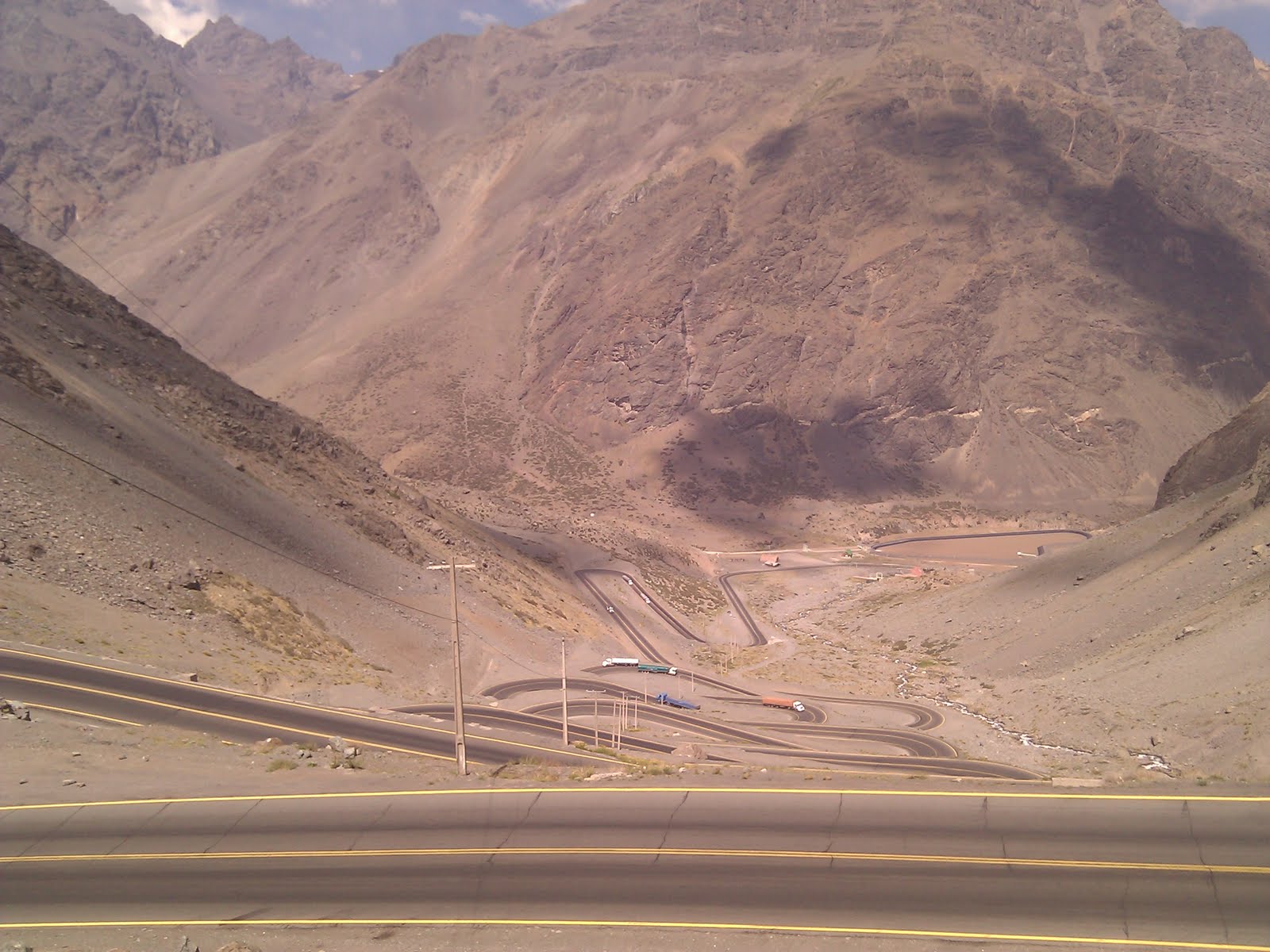
Shortly after midmorning snack, we turned a corner to see the first of the hairpins, and we knew the real climb was about to begin.
There are 29 numbered switchbacks in all (photo), the first 20 in one tightly woven set and the rest up the remainder of the ascent to the portillo ski resort. There's something really quite magical about climbing switchbacks. (In a strange way they're more fun to go up than down - for tandem descents we prefer nice straight roads which makes this pass a perfect choice for doing in the direction we are going). As you climb you get a real feeling of your progress. And it was very noticeable that this was the point that passengers started leaning out of passing cars cheering and taking photos, which just got louder and more frequent the further up we got. At one point we even saw a juggernaut driver taking a snap of us, whilst simultaneously negotiating an inside lane hairpin bend!
The portillo ski resort is at about 2800m but with no snow anywhere in sight it was a strange image. We pressed on past, around a long stretch of roadworks, and then through a long covered section of road that we were glad to put on the rear lights for. Then, on emerging we saw the flags that mark the start of the 3km tunnel between the countries, and off to the right the dirt track that leads up to the Cristo Redentor monument that stands at the summit of the natural pass. Decision time. At this point we were at 3200m, the highest we'd ever cycled, and the highest we'd been with full touring luggage by about 2 vertical km! It's another 600+ meters up to the summit, and as the weather was looking suspect and the day getting on, we decided the sensible option was to take the tunnel. Not that we're big fans of sensible options!
Bikes are not permitted through the tunnel, but a very efficient system is in place such that within a couple minutes of reaching the entrance a man appeared with a small truck and loaded the bike and luggage in, for a free lift through to Argentina. Whereas motor vehicles get to pay to drive through!
Sure enough, we emerged the other side into a rain shower that soon turned to hail, feeling glad we'd already donned rain jackets before loading the bike on the van as it's the most convenient way to carry them.
After 15km of rapid if damp going on painful descent we reached customs, which is very strangely a combined Chile / Argentine post. Very odd to see the respective authorities sharing offices and chatting to one another, when the early crossings we did in the south still have multi kilometer demilitarized zones to stop them taking shots at one another - or so it feels like!
Beyond the customs point is puento del Inca, an intriguing natural bridge with small settlement built around it, where we have stopped to camp. This area has base camps for folks attempting ascent of cerro Aconcagua, so has quite a different feel to the ski resort the other side. The valley is completely different too, being long and stretched out, and rocks of amazingly varied colours from what we have seen so far; looking forward to seeing more on the 200km descent to Mendoza tomorrow!
map
No comments:
Post a Comment
Note: Only a member of this blog may post a comment.